Marj TONINI - A data mining approach for natural hazard susceptibility
IDYST seminar
Lundi 7 octobre 2019 - 16h15 à 17h00 - Géopolis - 1620
The recent development of methods allowing to perform intelligent data reduction is a central issue in environmental science. Availability of massive digital geo-referenced databases led GISscientists to search for new tools able to deal such complexity. In this context, innovative techniques based on pattern recognition and data mining can be employed to find a structure in the data, to map susceptibility areas for a given environmental natural hazard and to address towards prevention and forecasting measures.
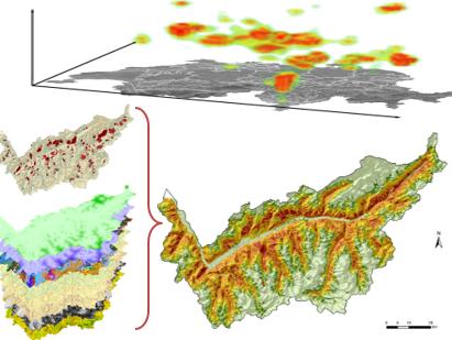
This presentation focuses on the investigation of two natural phenomena, notorious for having a negative effect on humans and the environment: landslides and wildfires. In the first part, we will explore the ability of global and local cluster indicators (the Ripley’s K-function and the 3D-Kernel density estimator) to analyze the spatio-temporal pattern distribution of these hazardous events and to support the elaboration of 3D-density maps. Results revealed the presence of clusters at different scales, measured in terms of distances (in space) and frame periods (in time). Statistically significant local clusters were also detected and related with the surrounding meteorological condition and extreme events, allowing to identify possible triggering factors.
In the second part, the application of a Machine Learning (ML) based approach for the spatial modeling of landslides and wildfires susceptibility will be introduced. In a broad sense, ML includes a class of algorithms for the analysis, modelling and visualization of data, and perform particularly well to model environmental and anthropogenic hazard, which naturally present a complex and non-linear behavior. In my studies I applied Random Forest (RF), an ensemble supervised ML algorithm based on decision trees allowing to model the hidden relationships between a set of observations and the environmental predictors. After a training procedure, necessary to calibrate the hyper parameters of the model, the probabilistic outputs were used to elaborate susceptibility maps. Moreover, RF directly provided the measurement of the importance of each variable, allowing to rank the predictors based on their relative contribution to the model. Research outputs consist of susceptibility maps of wildfires in Liguria Region (Italy) and of landslides in Canton Valais. Finally, the exportability of the model to a dataset of different nature, consisting of archeological Roman sites recovered in Canton of Zurich, will be presented and discussed.
György Hetenyi